
Technology Solutions
With help from our technology partners, we aim to equip conservation teams with free, integrated technologies for a 360-degree view of vast protected areas. Our independent advice helps our partners secure, plan, and implement appropriate cutting-edge tools and digital infrastructure that offer actionable insights and enhance decision-making.
Solutions range from landscape-scale connectivity, communications, Earth Observation, IoT sensors, AI analysis and a range of protected area management tools. Together, they provide real-time intelligence that enables rapid alerts, data-driven conservation and swift action to tackle habitat loss, poaching, coexistence, encroachment and management of natural resources.
Data-driven Conservation Management and Protection
We integrate connectivity, sensors and satellite data for real-time ecosystem monitoring, threat detection, and community-led stewardship.
Technology and Support
We facilitate the donation of a technology ecosystem from corporate partners, without tie-ins, helping protected areas to:
Monitor, protect, and restore nature
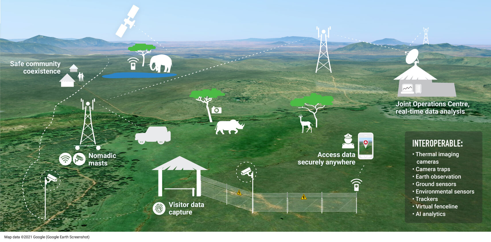
Network solutions: A multi-layered managed network providing connectivity via Wi-Fi and LoRaWAN, enabling roaming for seamless asset tracking across regions.
Operations centre: A centralised IT hub integrating conservation technologies for real-time monitoring, coordination and response, streamlining data flow and decision-making to enhance security and conservation.
Data management & analysis: An Actility-donated network server and NTT-Data Connected IoT application server, that manages and transports data to EarthRanger for real-time situational awareness. Interactive coverage mapping, alerts and analytics enable wildlife tracking, threat detection and informed conservation decisions.
Earth observation: We help partners access Airbus’ high-resolution satellite imagery, AI-powered analysis and on-ground sensors for threat detection, ecosystem assessments, land-use planning and wildlife corridor creation.
Get early warning for rapid intervention
Security detection: Boundary-based incursion detection using physical and/or virtual boundaries.
Tracking: Long-lasting monitoring to optimise resource deployment, providing accurate locations of assets including wildlife, vehicles, boats and ranger patrols.
Real-time video and image solutions: Various types of cutting-edge technologies.
Environmental sensing: Monitors natural resources and habitats, which are critical to the success of conservation programmes, including surface-water sensing and satellite data integration.
Communications: Enabled by implementing VoIP-unified communication solutions and onboarding digital radio systems onto the network architecture.
Plan, support and sustain solutions locally
Independent advice on proven tools: With a track record of deploying solutions in some of the world’s most remote and challenging terrains, CCF manages everything from scoping and planning to installation and ongoing support, ensuring resilient, technology-driven conservation.
Locally based CCF support team: Backed by the private sector support team to handle maintenance services, break/fix services and crisis management.
Expand with new integrations: Working with the conservation community to integrate and harness innovations in sensing as they develop.
Data privacy and security: Protocols to keep sensitive information safe.
Training and capacity-building: We’re soon launching the Protected Area Technology Career Path, a course designed to develop technology champions who can sustain tools that enhance species and ecosystem protection.
Innovation
We harness breakthrough technologies, unlocking innovation and scaling effective approaches:
Field-based testing facility to trial new technologies
Protecting wildlife and ecosystems demands collaboration and a multidisciplinary approach. We unite cross-sector expertise with cutting-edge products and services from our partners to advance and adapt.
At our test sites, engineers and partners trial the latest tools, from AI-powered analytics and satellite imaging to groundbreaking IoT sensing technologies. Through strategic commercial partnerships, we secure durable, high-performance equipment, rigorously evaluate its conservation potential and identify efficiencies that reduce costs for field operations. Promising technologies, once proven, are then integrated into the Connected Conservation technology ecosystem and scaled up.
Simplifying sensor selection for conservation: IoT sensors enhance conservation, but choosing the right one is complex. Clear criteria, standardised guidelines, and collaboration are key. CCF is advancing an AI-driven assistant that simplifies this process, helping users quickly find the best-fit IoT sensors, saving time, money and effort.
Bringing innovation to the ground
We're pushing innovation to enhance nature protection and ecosystem management:
Ecosystem Insights, integrating High-Res Satellite imagery, AI and in situ data: With the Airbus Foundation and local partners, we are applying High Resolution Satellite Imagery (50 cm, 30 cm and 15 HD) to monitor Earth’s Systems in unprecedented detail. We're exploring new ways to gain insight by combining this imagery with Artificial Intelligence (AI) and in-situ field data, such as wildlife tracking, field reports, environmental sensors and camera traps for rapid assessment and decision making. We’re scaling and sharing successes through our Ecosystem Insight Hub.
AI-powered conservation intelligence: Supporting the refinement of AI across multiple technologies, to help systems provide insights for conservation action.