![]()

Using Satellite Imagery to Build Foundation of Elephant Corridors in Namibia
Authors | Christin Winter and Chris Pitot (EHRA) and Japheth Kimeu (CCF)
- Ecosystem extent
- Ecosystem connectivity
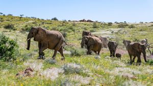
- Namibia’s desert-adapted elephants face an urgent crisis, with the southernmost population dwindling to 21 individuals - just a fraction of the 2,500 - 3,500 that lived in the Namib region in the 18th century.
- Habitat loss and fragmentation due to agricultural development have increased the frequency of human-elephant conflicts and retaliation killings. The Elephant-Human Relations Aid (EHRA) has been working with communities and farmers to reduce this conflict in Namibia.
- The study uses donated high-resolution (HR) satellite imagery from the Airbus Foundation and on-the-ground wildlife tracking sensors and data analysis from EHRA and the Connected Conservation Foundation to map elephant movements and identify key motivators.
- Elephants were found to prefer flat areas with healthy vegetation and water sources, often breaking through electric fences to access man-made water points. Their movement also avoided densely populated areas, highlighting the need for careful land-use planning.
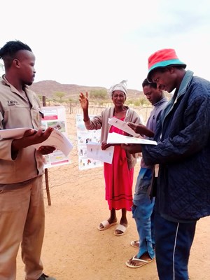
- This data, shared with local communities through EHRA workshops, informs better land management decisions, such as planning elephant corridors to reduce conflict and promote safe migration routes.
Objectives
Introduction
Land conversion is driving habitat loss and fragmentation on a global scale, with Sub-Saharan Africa experiencing significant impacts due to the expansion of agricultural development corridors. These corridors, while boosting economic growth, are fragmenting dryland and savanna ecosystems and disrupting critical wildlife migration routes and ecological connectivity. In Namibia’s Kunene region, this issue is particularly pronounced, as desert-adapted elephants, already navigating one of the most arid landscapes on Earth, are increasingly forced into human-dominated areas in search of food and water. According to Weidlich (2008) and Hauptfleisch (2018), this growing overlap between elephant habitats and farmlands has intensified human- elephant conflict, leading to crop destruction, water source depletion and, in some cases, retaliatory killings.
Failure to understand migration dynamics and their drivers endangers the successful protection of animals and is likely to exacerbate HEC (Bohrer et al., 2014). Establishing and restoring elephant corridors is crucial, and satellite imagery has proven to be a powerful tool in identifying, planning, and monitoring these vital pathways.
This project focuses on Namibia's southernmost population of desert-adapted elephants, which comprises just 21 individuals. Since 2003, the Elephant-Human Relations Aid (EHRA) has collaborated with local communities and landowners to protect these iconic elephants, striving to ensure their survival beyond the boundaries of Namibia's national parks.
This research aims to support EHRA by analysing elephant movements and their motivating factors and studying the environmental characteristics of the movements in commercial farms of the Kunene and Erongo regions using Geographic Information System (GIS) and Remote Sensing (RS) techniques. This project has been supported by the Airbus Foundation and the Connected Conservation Foundation. Their contributions include HR satellite imagery, funding and expert guidance in GIS, machine learning and Earth Observation throughout the study.

(C) Hannah Peck
Study area
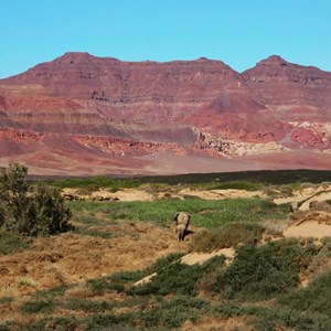
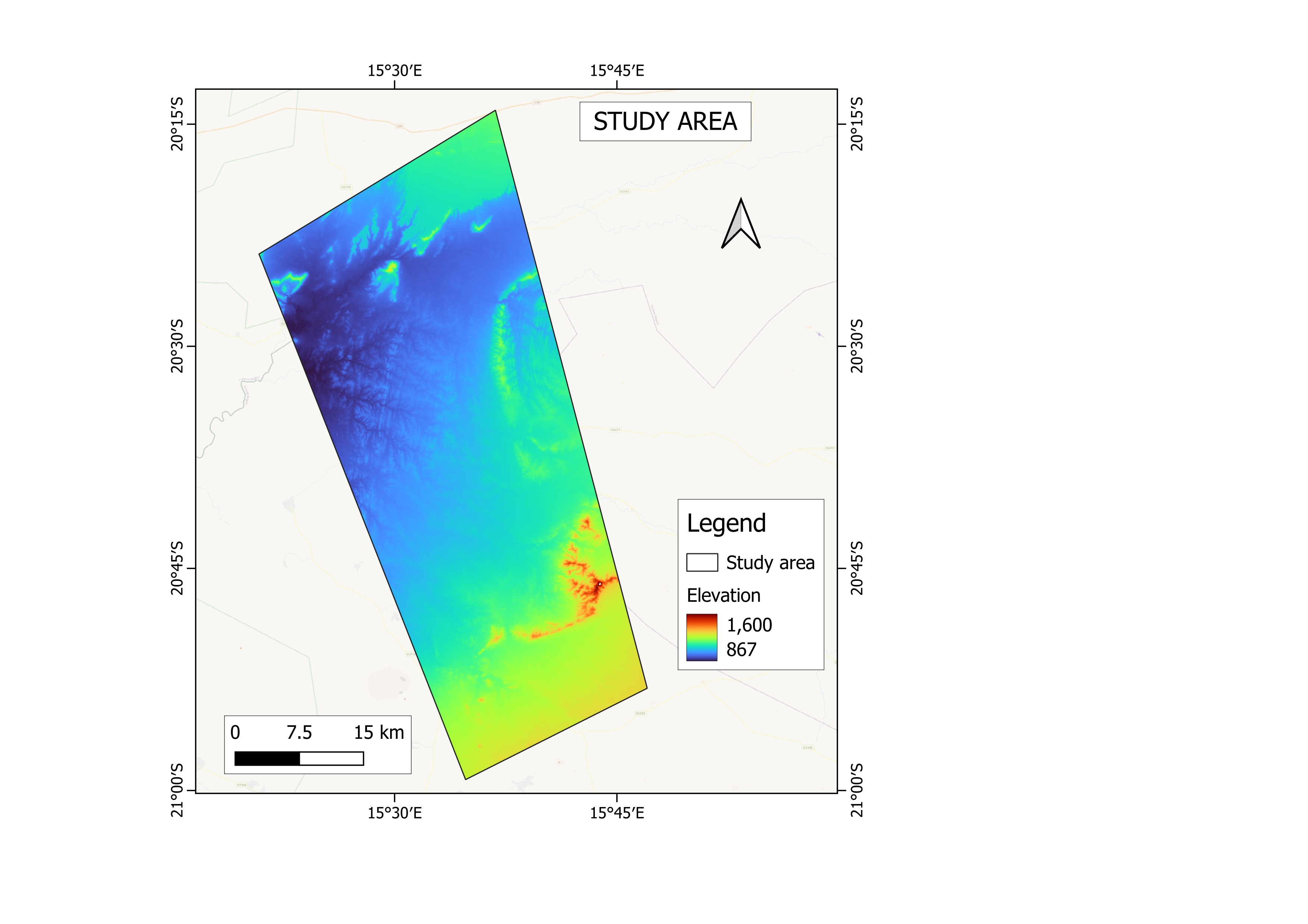
The study area lies on the borders of the Erongo and Kunene regions of Namibia between -20° 00’00’’ and -21° 00’ 00’’ South and between 15° 25’ 00’’ and 15° 50’ 00’’ East covering about 200 hectares. The area experiences low rainfall with an average of 54mm per year with the highest rainfall of 145mm in January. June is the driest month and experiences little to no rainfall. Elevation in the study area ranges from 870m to 1600m above sea level.
Methodology and analysis
Data
Satellite imagery for this study was obtained from the Airbus Pleiades satellite constellation that consists of Pleaides-1A and Pleiades-1B, which were launched in 2011 and 2012, respectively. The satellites provide very-high-resolution (VHR) imagery at 50cm with a 20 km swath width. The images were captured between July 2023 and April 2024. Other datasets include topography, river network, population density, fence lines, farms and water points. EHRA provided elephant movement data captured by GPS collars between January and April 2024.
Tables 1.1 and 1.2 below describe imagery, ancillary and elephant telemetry data, respectively.
Table 1.1: Satellite imagery and ancillary data
|
Data |
Description |
Date/Period |
Source |
|
Pleiades imagery |
VHR Airbus Pleiades satellite imagery of 50cm resolution covering 73 by 32 Km. |
July 2023 – April 2024 |
Airbus OneAtlas |
|
Topography |
SRTM Digital Elevation Model data representing earth's terrain. Includes elevation, slope, aspect, etc. at a resolution of 30m. |
- |
USGS Earth Explorer |
|
River network |
Free-flowing rivers network based on SRTM elevation data |
- |
WWF HydroSHEDS |
|
Population density |
Distribution of human population in the study area at a resolution of 1 km. |
2020 |
Gridded Population of World (GPW) |
|
Fencelines |
Manually Digitized from secondary data sources of commercial farms in the study area |
2024 |
EHRA |
|
Farms |
Commercial private farm boundaries in the study area |
2024 |
EHRA |
|
Water points |
Water surface points including boreholes, wells, dams and pans, in the study area. |
2023 |
Airbus Pleiades |
Table 1.2: Elephant movement data
|
Collar ID |
Number of Points |
Number of Points Used in Analysis |
Transmission Interval |
|
Africa Elephant 4791 |
2516 |
2516 |
Every 1 Hour |
|
Africa Elephant 6184 |
3611 |
3611 |
Every 1 Hour |
|
Africa Elephant 6331 |
2854 |
2854 |
Every 1 Hour |
|
Africa Elephant 6332 |
2867 |
2867 |
Every 1 Hour |
|
Africa Elephant 6333 |
2855 |
2855 |
Every 1 Hour |
|
Africa Elephant 6334 |
2854 |
2854 |
Every 1 Hour |
|
Africa Elephant 6581 |
2856 |
2856 |
Every 1 Hour |
|
Africa Elephant 6582 |
2869 |
2869 |
Every 1 Hour |
|
Africa Elephant 7163 |
1029 |
1029 |
Every 1 Hour |
|
Africa Elephant 7164 |
2856 |
2856 |
Every 1 Hour |
Feature extraction
i. Land use, land cover and habitat mapping
Airbus Pleiades images were classified using Random Forest (RF) and Support Vector Machine (SVM) algorithms. The classification was done in Google Earth Engine. The table below shows the parameters used in the classification for each algorithm.
|
Algorithm |
Parameter |
Value |
|
Random Forest |
Number of Trees (n) |
1000 |
|
Support Vector Machine |
Kernel |
Linear |
The resulting land cover map included a total of 4 land cover classes: Trees, Shrubland, Grassland and Bare areas. Based on the land cover map, a habitat map was derived according to the International Union for Conservation of Nature (IUCN) Habitat Classification Scheme by relating European Space Agency (ESA) Climate Change Initiative (CCI) land cover classes to IUCN Level 2 habitat types.
ii. Home range
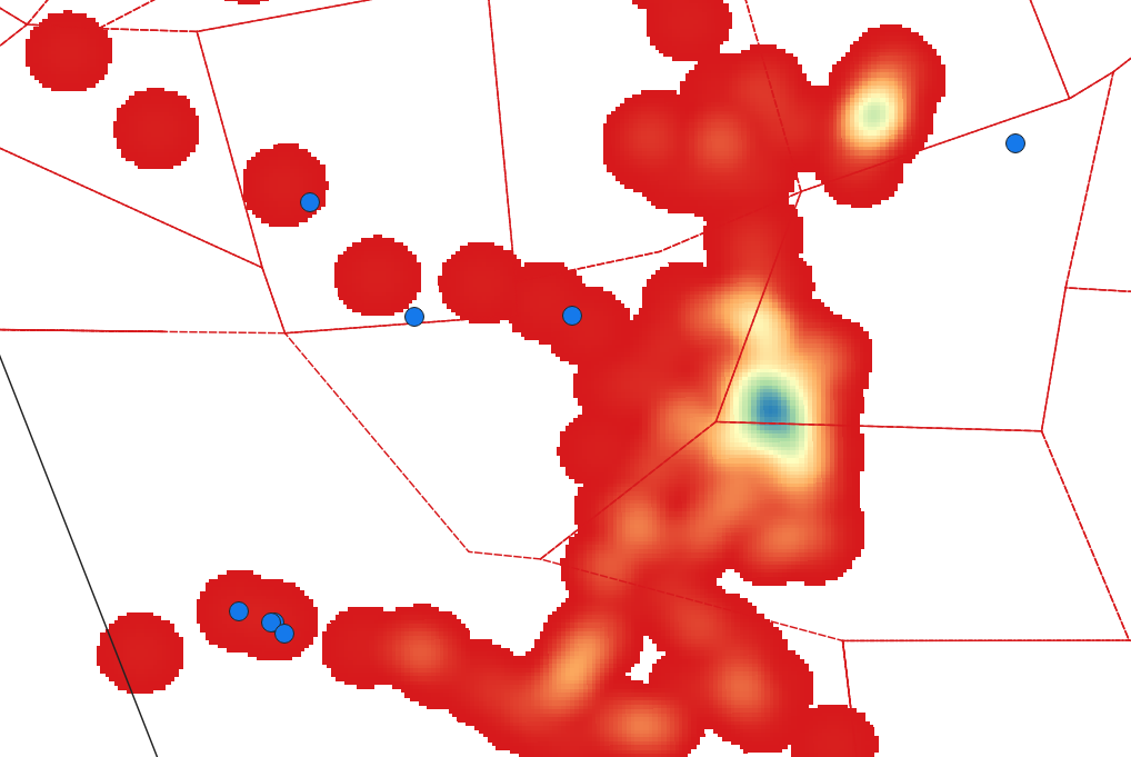
Using the GPS collar data, a heatmap was created for each elephant at a radius of 1 kilometre using Kernel Density Estimation (KDE). The layers were analysed to identify motivators in the areas of high density.
iii. NDVI
A Normalised Difference Vegetation Index was computed using Red and Near Infrared bands of the Airbus Pleiades imagery.
iv. Slope
The Slope was derived from the SRTM elevation data and classified into 3 categories: steep, moderate, and gentle slopes.
V. Human population density
The population density of the study area was calculated from the global dataset Gridded Population of World (GPW) and categorised into four classes: high, medium, low, and very low.
Vi. River network
Rivers with an order of 2 were selected for this analysis primarily because the region is characterised by arid conditions, making these secondary streams critical sources of water and food in such a dry environment.
An analysis of VHR Airbus Pleiades imagery was conducted in Google Earth Engine to detect water sources using the Modified Normalized Difference Water Index (MNDWI) complemented by extensive field validation to ensure accurate detection and verification of water bodies. The combination of high-resolution satellite imagery and ground truthing provided a comprehensive approach to identifying water sources in the study area.
Analysis and Results
All the layers were loaded and overlaid in the Google Earth Engine platform for easier analysis. Elephant collar data were compared with each environmental and ancillary variable to identify patterns.
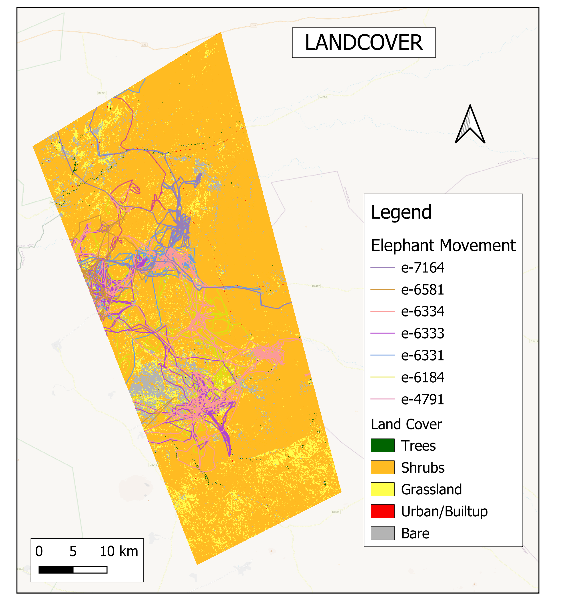
a. Land cover and habitats
Results show that elephants predominantly spend their time in grassland and shrubland habitats. These habitats provide essential resources such as grasses and shrubs for feeding, making them critical for daily activities like grazing and browsing. In addition to grasslands and shrublands, the elephants were observed moving along river channels characterised by trees. Trees provide additional food, water, and shelter, especially during dry seasons and when water sources become limited.
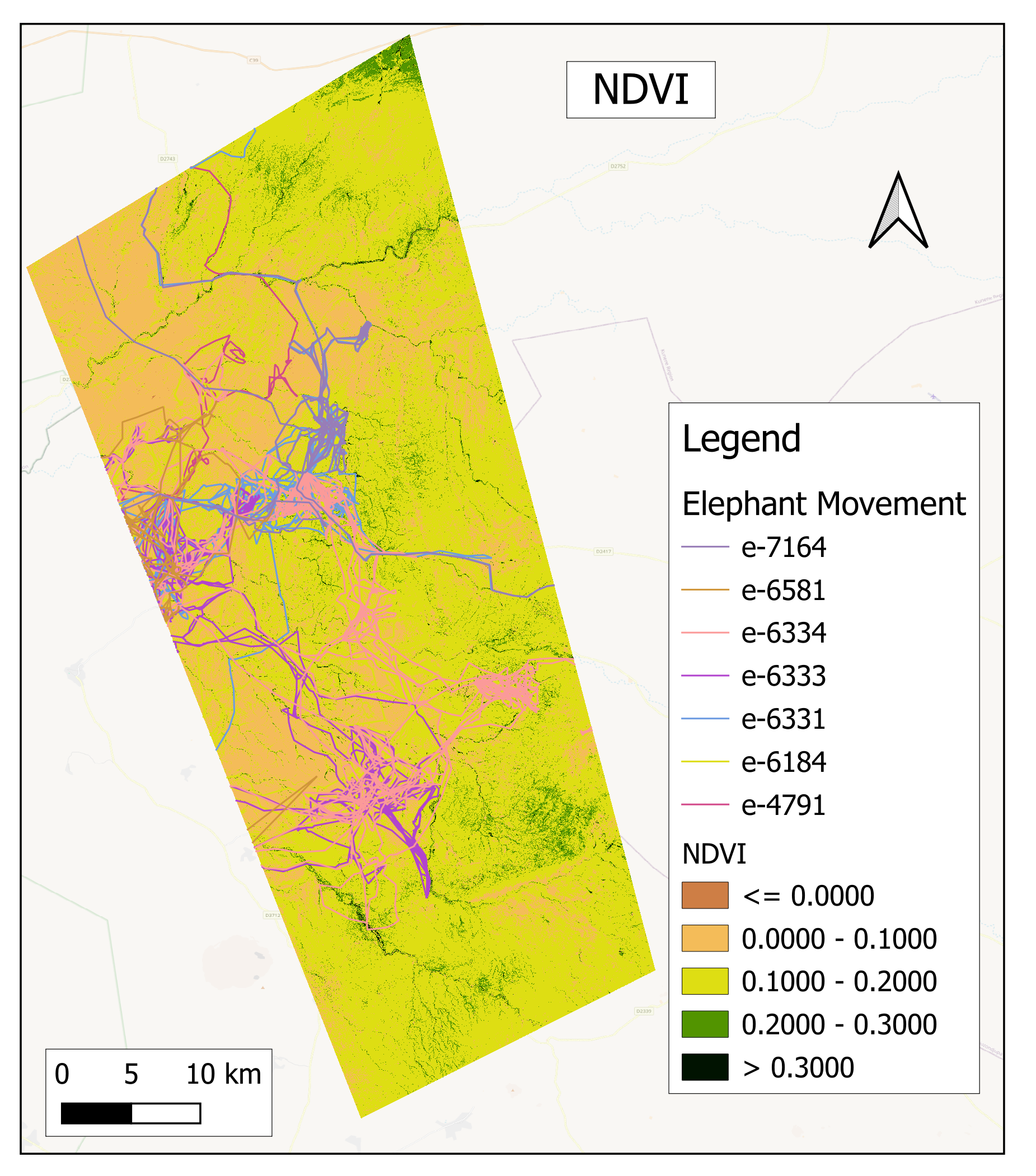
b. NDVI
NDVI analysis shows that elephants frequently move across landscapes in search of healthy vegetation. Their movement is often concentrated in regions with abundant green vegetation as these areas provide better food resources. This suggests that elephants are selective in their movements, optimising their routes based on vegetation availability and health.
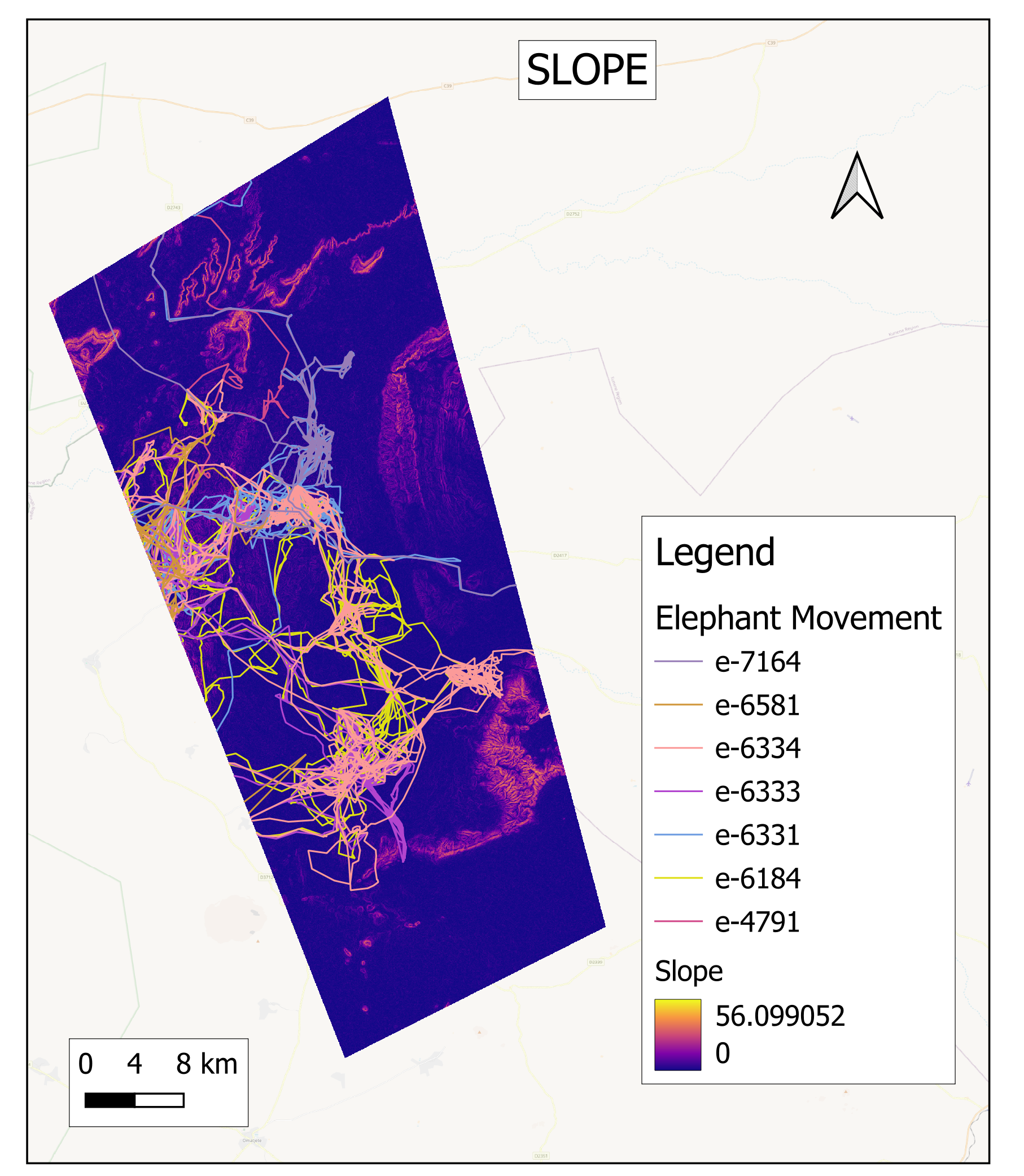
c. Slope
Analysis shows that elephants prefer moving across gentle flats rather than steep slopes. Flat terrain allows for easier movement and access to resources, while steep slopes may present physical challenges and energy costs, so elephants avoid them. This tendency to navigate through flat areas helps optimise their energy use as they search for food and water across the landscape.
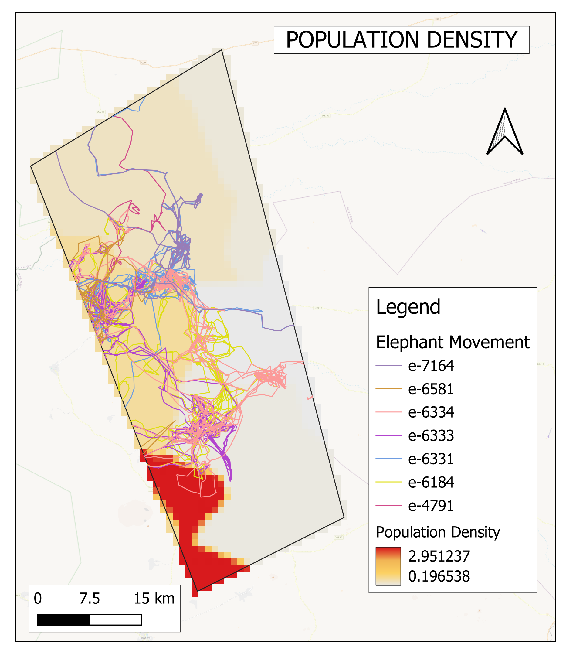
d. Population density
These Elephants tended to avoid densely populated areas, with their movement concentrating in regions of low population density. This behaviour likely reflects their efforts to avoid human settlements, reducing the risk of conflict with people. Encounters with human populations can lead to harmful situations, such as crop raiding or retaliatory harm, which elephants instinctively seek to avoid. Consequently, their movement patterns highlight a preference for safer, less disturbed areas where human presence is minimal, reducing potential conflicts.
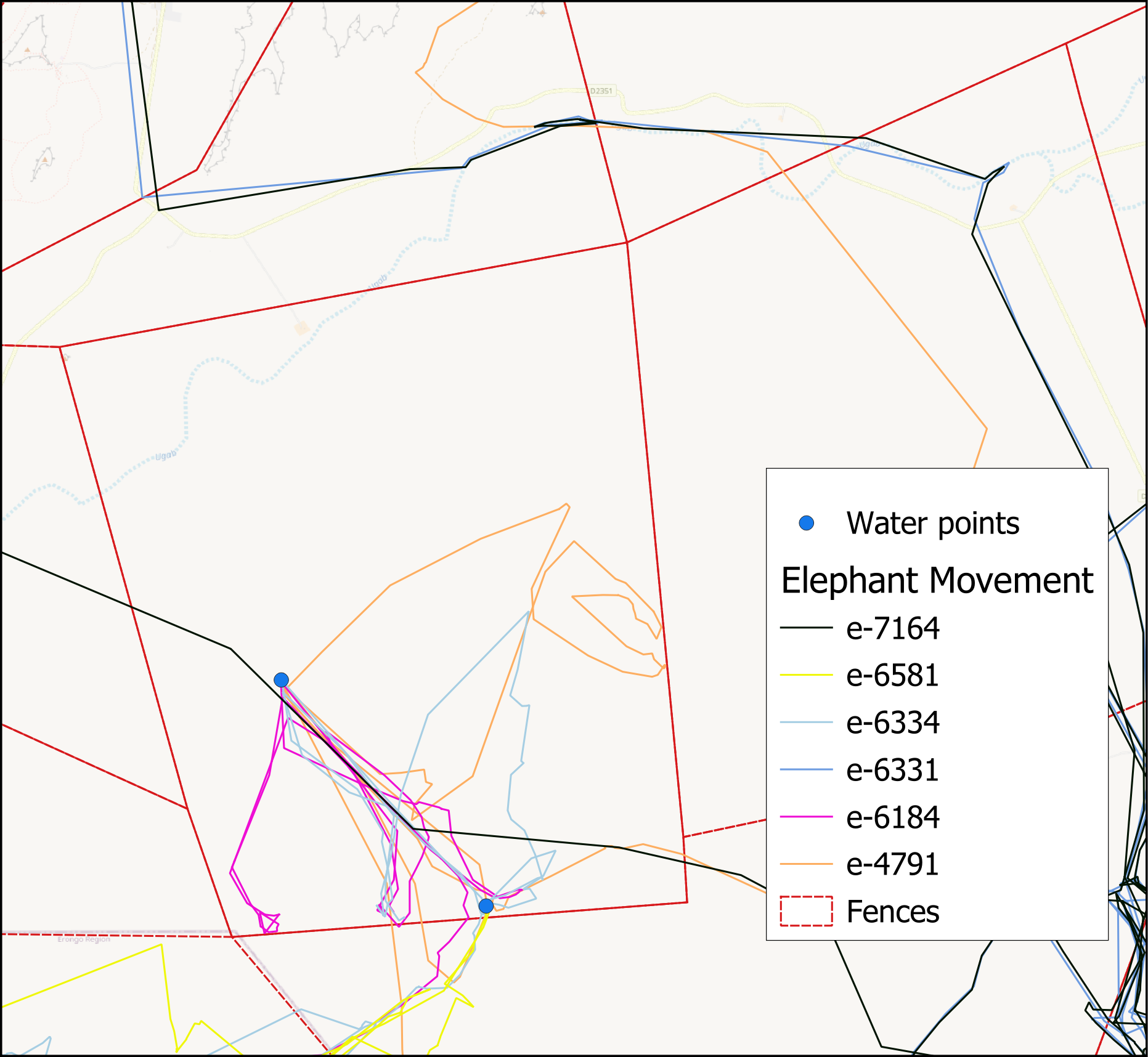
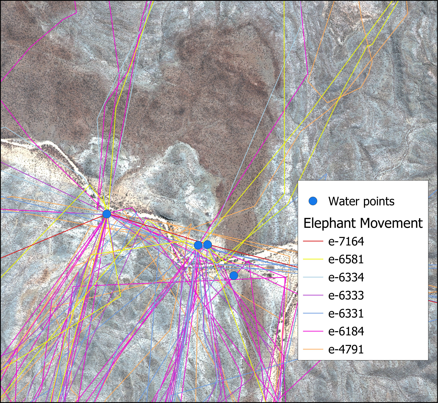
e. Man-made water points and fence lines
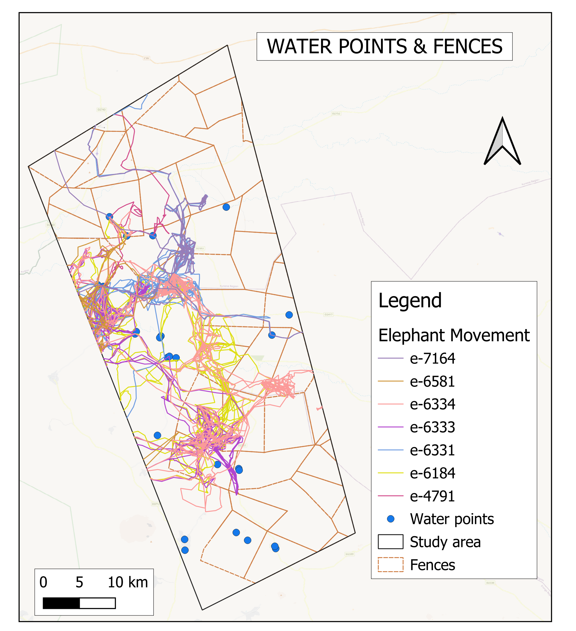
Elephants in the study area are frequently observed moving across the landscape in search of water points, which are vital for their survival. Nearly all man-made water sources in the region have been visited multiple times by elephants tracked during the study. In some cases, elephants have been observed breaking electric fences to gain access to water points located within commercial farms.
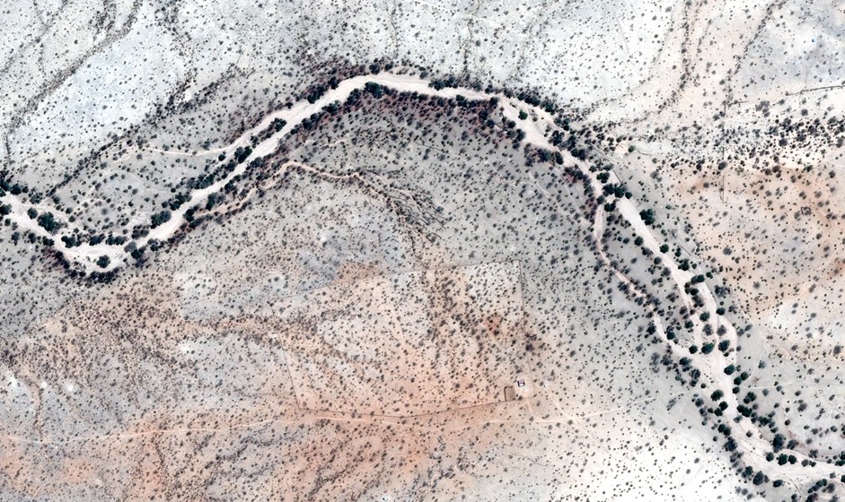
However, in areas where high-voltage electric fences are present, elephants appear to be restricted, as these fences prevent them from crossing. Instead, they often move along the fence lines, attempting to find an entry point or alternative access to water sources. This behaviour underscores the importance of access to water availability and the lengths elephants will go to meet their hydration needs. In the left image, you can see how the elephant's movement is repeated and restricted by fencing.
f. Home range
Based on the heat density analysis, elephant movement from January to April 2024 was concentrated in areas with healthy vegetation and near water sources. Elephants repeatedly sought out regions with abundant resources, indicating patterns of movement and their reliance on productive landscapes for sustenance.
Map output and review
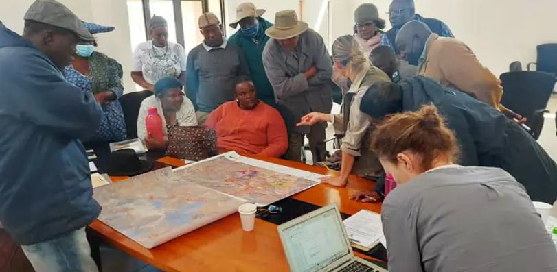
EHRA has conducted community workshops with key stakeholders, using identified motivating factors and elephant movement patterns to inform collaborative efforts in delineating elephant corridors and integrating farm planning, including:
Commercial farmers: EHRA, commercial farmers and the Ministry of Environment, Forestry and Tourism (MEFT) convened to address the significant financial impact of elephants traversing commercial farms. Farmers validated conflict hotspots, water points and fences, providing key data that was digitised for analysis. EHRA also set up an EarthRanger platform, giving farmers controlled access to live elephant collar data to deter elephants sustainably and repair fences quickly. These initiatives have greatly improved collaboration and conflict mitigation.
Communal farmers, conservancies and traditional authorities: The maps highlighting elephant movement and conflict areas helped stakeholders fairly prioritise mitigation projects for maximum impact.
Tourism industry: Using the movement, situational and satellite data, EHRA demonstrated how unethical tourism threatens this vulnerable population. In partnership with TOSCO, major tourism associations, and MEFT, EHRA is leading the Ethical Elephant Tourism campaign to promote responsible practices that support conservation.
Conclusion
Elephant movement in the study area is shaped by a complex interplay of environmental and human-related factors. These animals gravitate toward regions with man-made water points and abundant vegetation, particularly those with high NDVI values (grasslands, shrublands and river channels). They also favour gentle, flat terrains over steep slopes, which are easier to navigate. Human presence also significantly influences their behaviour, with elephants actively avoiding densely populated areas, most likely to reduce conflict. Interestingly, even when natural dams are full, elephants continue to drink from man-made water points, raising questions about exposure, proximity to human activity, or other behavioural drivers that warrant further study.
Water access remains a primary motivator, with elephants breaching electric fencing to reach man-made watering holes on commercial farms. However, high-voltage fences largely dictate their movement, forcing them to trace fence lines in search of crossings and alternative routes.
As elephants move through farmland, human- wildlife conflict increases. This study provides crucial insights into seasonal movements and water source preferences, informing conservation strategies. Early findings are already guiding land-use decisions. At Otjongoro Farm, for example, elephant movement and satellite data revealed heavy use of a natural spring. The farmer agreed to donate that land to the elephants in exchange for the protection of the rest. EHRA funded an electric fence, creating an ‘elephant corner’ that elephants have already begun using.
With all herds and six males now collared, ongoing tracking will refine conservation efforts. Currently, in the rainy season, elephants are concentrated on commercial farms. Future data collection for the wet season will further improve conflict mitigation and corridor planning.
Further research
The next phase will extend the analysis to the wet season, allowing for the incorporation of annual data to inform the planning and construction of elephant corridors. A future development of this research could involve creating a machine-learning algorithm to detect man-made water points in satellite imagery. This tool would enable analysis over a larger area of interest (AOI), helping to identify key drivers of elephant movement.
Full study copywritten to Christin Winter and Chris Pitot (EHRA) and Japheth Kimeu (CCF).
Elephant collar data sources: EHRA, Namibian Ministry of Environment, Forestry and Tourism (MEFT) and Namibia University of Science and Technology (NUST)
EHRA
Project Leads
Christin Winter and Chris Pitot
EHRA works to create peaceful relationships between desert elephants and local communities in Namibia, Africa.